
I’m not sure when exactly when Amy and I committed to attempting the PCT, but the idea had been floating around for many years. Back in 2022, we nearly hiked it instead of the AT, but decided that we might as well try both at some point in our lives.
In October of 2024, we applied for PCT long distance hiker permits and scored two spots. We found ourselves in the uncomfortable, yet exciting process of uprooting our lives yet again. We paused our careers, terminated our lease, and shoved everything we owned into a 10-foot, metal box. I am reminded of how much I have accumulated over the years and feel a strange detachment to things that I would have previously considered essential.

When that is finally done, it is March 31, three weeks before our planned start date of April 20. Before heading to the southern terminus of the PCT, Amy and I spent some time with our loved ones. Visiting our spread out family was like embarking on a tour of the country.
We first flew from Pittsburgh, PA to Raleigh, NC where we spent six days with Tyler, Olivia, and our adorable 1-year-old niece, Clara. At the end of the week, we drove towards Charlotte, NC and spent a day at Carowinds, then camped for a night at Congaree National Park.

Here, my parents picked us up and drove us southeast to Charleston, SC. We toured the USS Yorktown and spent a few days exploring the holy city, before flying across the country to Las Vegas, NV.
We stayed with Hali, Adam, Jillian, Lucy and Joey for the next week and half. We managed to squeeze in a hike or two, but these were some of the last nights that Amy and I would have a real bed and we made sure to take advantage of that.

On Friday, April 18, we took a quick hopper flight to San Diego, CA. Hali, Adam, Jillian, Lucy, Amy, and I enjoyed the weekend together, saw giant pandas at the San Diego Zoo, and relaxed by the water on Ocean Beach. We also drove to a grocery store to buy food for our first four days of hiking. Before we knew it, it was time to head to Mexico.
4/20 – Day 1
12.4 miles from PCT Southern Terminus to Dispersed Campsite
My eyes popped open at 5:30am on the overly-plush mattress of our rental home in San Diego. The anticipation was overpowering. At 28-years-old, not many things keep me awake like a kid awaiting Santa.

I feigned sleep a while longer, then got up and finished packing the remainder of my gear. By 10:00am, our crew of Hali, Lucy, Jillian, Amy, and myself had checked out and scooted over to a local cafe for breakfast. After the final bite of french toast, it was finally time to head to the southern terminus of the PCT, located about an hour drive away in Campo, CA.

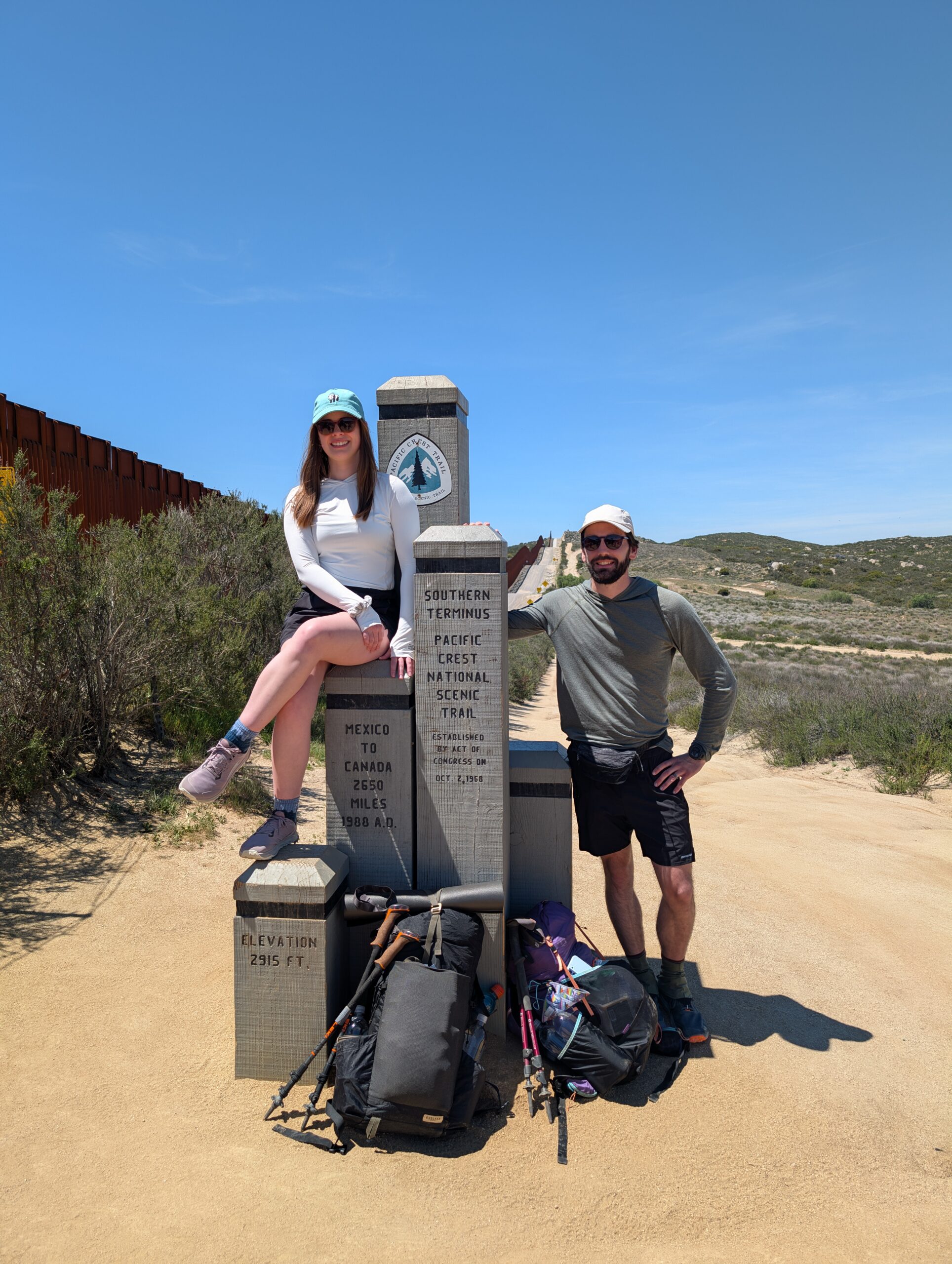
The drive down was beautiful and I was immediately shocked at the lush greenery of this part of southern California. We made a pit stop at the Campo Green Store for stove fuel, then drove to the trailhead. A short dirt road took us directly to the PCT monument, standing proudly in front of the towering border wall dividing USA and Mexico. We snapped some photos as a group, then walked a bit down the road to actually approach the wall and stick our arms through to say, “we’re in Mexico!”

It was just before 1:00pm when Amy and I began our 2,650 mile northbound hike of the Pacific Crest Trail. The feeling was bittersweet, but also as Amy mentioned later, slightly anticlimactic. After many months of preparation and planning, the day finally arrived, we started from the trailhead, and just… walked. No fireworks, just some sad goodbyes followed by several hours of processing the situation we put ourselves in. We were excited of course, but it did not feel real just yet.

Only a half mile in, we came upon Camp Lockett and a handful of other hikers gathered. We didn’t hang out long, but checked the hiker box and found that someone apparently no longer needed their sleeping bag. We also weighed our packs on a hanging scale. With four days of food and three liters of water, mine was just shy of 27lbs, while Amy’s was about 25lbs.

The trail itself began about as easy as any I’ve ever hiked, with smooth, sandy hills and level switchbacks. The border wall was visible for most of the day. It was 80° and sunny, with a shady tree only every few hundred yards or so. Starting in the heat of the day may not have been the smartest decision in retrospect.

We crossed our first stream after only 2 miles, then another in 2 more miles. It seemed that desert had plenty of water! However, as 5:00pm neared, we immediately understood why it is so common for hikers to partake in mid-day siestas on the PCT. The weather was now absolutely ideal for hiking and we cruised a few more miles before sunset.

Due to our permit situation, we needed to camp shy of the Cleveland National Forest boundary. We pulled over at nice clearing behind a boulder, sharing the space with two other hikers, History and Pixie. Amy and I shared a delicious hot dinner of beans and rice as we watched our first sunset of the trail behind the hills. Then, in true PCT fashion, we left our tent in the pack and laid out for the night under the stars.


4/21 – Day 2
20.2 miles from Dispersed Campsite to Cibbets Flat Campground
When cowboy camping, you have no option but to rise with the sun. We started our second day of hiking just after 7:00am, which is quite early by our standards. Despite literally just starting this trail the day before, we were motivated by a restaurant at Lake Morena 7 miles away and steamrolled ahead as if we were desperate for a decent meal.
The dusty trail descended to Hauser Creek and then climbed back out over the course of five miles. Closing into the reservoir, we caught a nice view of Lake Morena and made it to the park shortly afterwards. To our surprise, there were two separate parties providing trail magic to the hikers!

An Irish man who went by Sherpa was grilling burgers for a small crowd. He was an experienced PCT veteran and schooled us with plenty of good advice. The best part of the trail magic is that we no longer cared about paying for restaurant food.

Leaving the lake around 1:00pm, we walked through several miles of sandy, desert terrain. I invented a fun game I call Cactus Poke™, in which you and a partner must take turns pointing out a cactus that the other person must poke, less they forfeit. Spout got me pretty good with a strategic selection of a prickly pear cactus. Well played.

The sand gave way to a few miles of grasslands that almost seemed out of place. We crossed under Highway 8, followed Fred Canyon for a short while, then turned 0.7 miles down a dirt road to Cibbet’s Flat Campground. We logged our first twenty mile day of the trail, and though I was tired, it did not feel particularly strenuous.

A hiker we met earlier, Fiddlesticks, was waiting at the campsite, along with two bikers who were posted up for the night. They invited us over to their campfire after we setup. The bikers, Dave and Shawn, told us stories about their love for motorcycles. Then, they started probing us about backpacking: “What’s the point?”, “You sleep in that tiny tent?”, “How is that enjoyable?” I tried my best to explain to them how incredible the experience of thru-hiking can be, but I’m not sure it made much of a difference.
Either the whole world is crazy, or we are.
4/22 – Day 3
14.8 miles from Cibbet’s Flat Campground to Laguna Campground
It was a perfectly clear day and we hit the trail around 7:30am yet again. For the first time, we decided to enjoy some music on our morning stroll. This enabled some serious mile crushing. I clocked 18 minute miles more than once as we approached Long Creek.

After filtering some water, we continued the slow climb that was Mount Laguna. It was not much of a mountain in a traditional sense, rather a small recreation area, but we did crack 6,000′ in elevation. We entered a stretch with abundant Ponderosa Pine, the first confiers we’ve encountered in the high desert.

A short side trail brought us to the “town” of Mount Laguna and the Pine House Cafe. We enjoyed a lunch of burgers and French onion soup with the company of a dozen other hikers, including one “tramily” of four. Tramilies formed on day one are cult-like and should be avoided at all costs.

We left at 1:00pm and worked our way back to the trail, eventually falling into stride with NTS (pronounced “knits”, short for “Not Today Satan”). We chatted with her as the trail treated us to dramatic views of the Cleveland National Forest. We pulled off at Foster’s Point, where the silhouette of Mt. San Jacinto could just barely be made out over 80 miles away.

We were at the tail end of a no-dispersed-camping zone, but rather than push ahead, we chose to stop at another commercial site, Laguna Campground. It was a pleasant campground that was already occupied by a flock of red-headed woodpeckers, busily working away at the pines. The tree trunks were littered with holes from the woodpeckers and the holes were filled with nuts. The birds did not put them there, however. The squirrels use the holes like a safe deposit box to store their nuts!

Besides the critters, we also camped with NTS, Pixie, Froot Loop, Jess, Emma, and several others. We discussed the upcoming water situation, past adventures, camping gear, and everything in between. Before the sun even set, however, mostly everyone retired to their tents, hoping to catch some Z’s before another long day of hiking tomorrow.

What’s Next?
We’ll be in the desert for the first ~700 miles of the trail, which we expect to take us through the end of May. Upcoming are the first trail towns that we will pass through, as well as more mountainous desert.
How’s It Going?
Looking back on my journaling of the AT, I wished I had kept a better log of how I was feeling, physically and mentally, along the way. I’m planning to use this section to keep track of how Amy and I are doing as we progress.
To start, I am feeling very grateful for all of my family. They are so supportive and have assisted Amy and I in so many ways, including helping us move out, storing our belongings, providing a place to stay, and offering to ship gear/food to us on trail.
We are fortunate to start the trail healthy. Neither of us have an injury to report, however we are also not in particularly impressive hiking shape out of the gate. Our baseline is still relatively strong, but we regressed after completing the AT and it will take some time before we regain our “hiker legs”. Overall though, we feel strong, fast, and more than capable of handling the generally flat terrain of the desert section.
Food & Resupply
Another topic I love looking back on for previous hikes is what I ate. I’ll use this section to document some of our resupplies and give a general overview of what we are eating.
A goal that both Amy and I wanted to aim for on the PCT was to eat a bit healthier than we did on the AT. Maybe a good start is to give up the name Candyman… Being realistic, however, I still made sure to pack some Sour Patch Kids and Peanut Butter M&M’s, which are super calorie dense and easy to eat.

We prepared some of our dinners ahead of time. A few months ago, we purchased and dehydrated over 20 cans of black beans, then mixed portions with instant rice according to Andrew Skurka’s beans and rice recipe. I also prepped a few batches of Andrew Skurka’s peanut noodle recipe. As a reminder, Amy and I ate plain ramen noodles and couscous every night on the AT, almost exclusively. Both of these new recipes should be delicious either hot or cold and are definitely an improvement in taste and nutrition.

In total, we prepared about twenty dinners. We started the hike with five of them and the rest we left with Hali, who has graciously offered to assist in mailing resupply boxes as needed. Of course, we will need well over 100 dinners throughout the hike, but this was a good start.

I also found 5.5oz bottles of Fruity King soda (sold individually at Walmart for 33 cents each ) and bought one. I cleaned it out and filled it with olive oil to add to our meals for extra flavor and calories.
Gear Changes
I didn’t track updates to my gear as closely as I would have liked for the AT, so I’ll use this section to do that this time around. Since posting my gear list, I’ve made a few small changes:
- I am no longer starting the trail with MICROspikes, since Mt. San Jacinto is nearly snow-free already. I will carry them once we reach Kennedy Meadows
- I am going to carry my Enlightened Equipment APEX Torrid puffy jacket with me to start, since I think we will encounter nights below freezing in the desert
- I picked up a 1oz dropper bottle at Hobby Lobby and filled it with moisturizing oil that will help with dryness
- I added a SteriPod to my toothbrush that should keep it cleaner
- I threw in 50′ of utility cord for hanging food at night
Notes
I’ll include this section for miscellaneous information for future reference for myself, gear changes, expanding on certain events, or providing updates on the blog.
- I am going to let this trail rename me, but Amy has grown fond of Spout and will stick with it
- I’m planning to track each day’s hike on my Garmin Instinct 2X. I’m not totally convinced this is sustainable for the entire thru-hike, but I would like to have the data it provides, if possible
- To help preserve battery, I am recording using only “GPS” (instead of “Multi GNSS”), not tracking heart rate, and pausing everytime we take a long break
- Updating the website on my phone is difficult and ensuring the formatting looks good is even harder. If something looks off, feel free to comment because I might not even be aware
- I will probably reference Kennedy Meadows quite a bit early on. Kennedy Meadows South (KMS) is 703 miles into the PCT and marks the start of the Sierras for NOBOs. It is significant because the terrain changes dramatically, mountains will likely have more snow on them, difficulty is increased, strict/competitive permitting begins, and it is considered one of the most beautiful parts of the trail
- Amy and I were able to apply for “linked” permits through the PCTA lottery system, which allowed the two of us to secure permits for the same day
- Our appointment time for selecting the permit start date was Wednesday, October 30, 2024 – 02:07:35 PM Pacific Time
- The earliest remaining date that we reserved was Thursday, May 15, 2025
- Our original starting location was Campo, CA (mile 0) but we changed it to Soledad Canyon Rd (mile 444) on both of our permits in early April
- The PCT long distance permit exists to simplify the convoluted process of securing permits for all required sections of the trail
- We can use local permits or camp in public campgrounds for the two sections of the desert that require permits before KMS (Cleveland NF and San Jacinto Wilderness). I have already spoken with a PCTA ridge runner about this, told him our plan, and he gave us a thumbs up
- When deciding when to start, we knew we did not want to start too fast and risk injuring ourselves, but also didn’t want to under-plan. We estimated we could hike roughly 17 miles per day through the desert. To reach mile 444 by May 15, we chose to start on April 20
- We have no clue if this was a good idea yet. We might find the desert terrain exceptionally easy, arrive early, and have to wait for a few days in Acton, CA. We might travel slower than anticipated and have to figure out how to handle that. In either case, we think it is important to make sure we are at the permits’ starting location on the day we chose